WASHINGTON, D.C., Oct. 03, 2023 (GLOBE NEWSWIRE) — Two leaders in Earth science education, UNAVCO and the IRIS Consortium, have merged to create a new entity, EarthScope Consortium. The merger expands the availability of high-quality teaching resources for educators in K-12 education and higher education. Resources—including lesson plans and animations about real-world scientific phenomena—are available as open access materials, free of charge, just in time for the October 2023 Earth Science Week and International ShakeOut Day, October 19, 2023.
“Student engagement soars when real-world phenomena like newsworthy earthquakes are connected to the science standards they learn in their classroom,” says Michael Hubenthal, Program Manager for the EarthScope Consortium and Adjunct Lecturer for the Department of Teaching, Learning, and Educational Leadership at Binghamton University. “Teachers think of EarthScope as a trusted hub of user-friendly resources and data for their teaching, and they tell us that they can always count on us to be scientifically accurate and available through open access.”
Top Earth Science Resources for Teaching and Learning
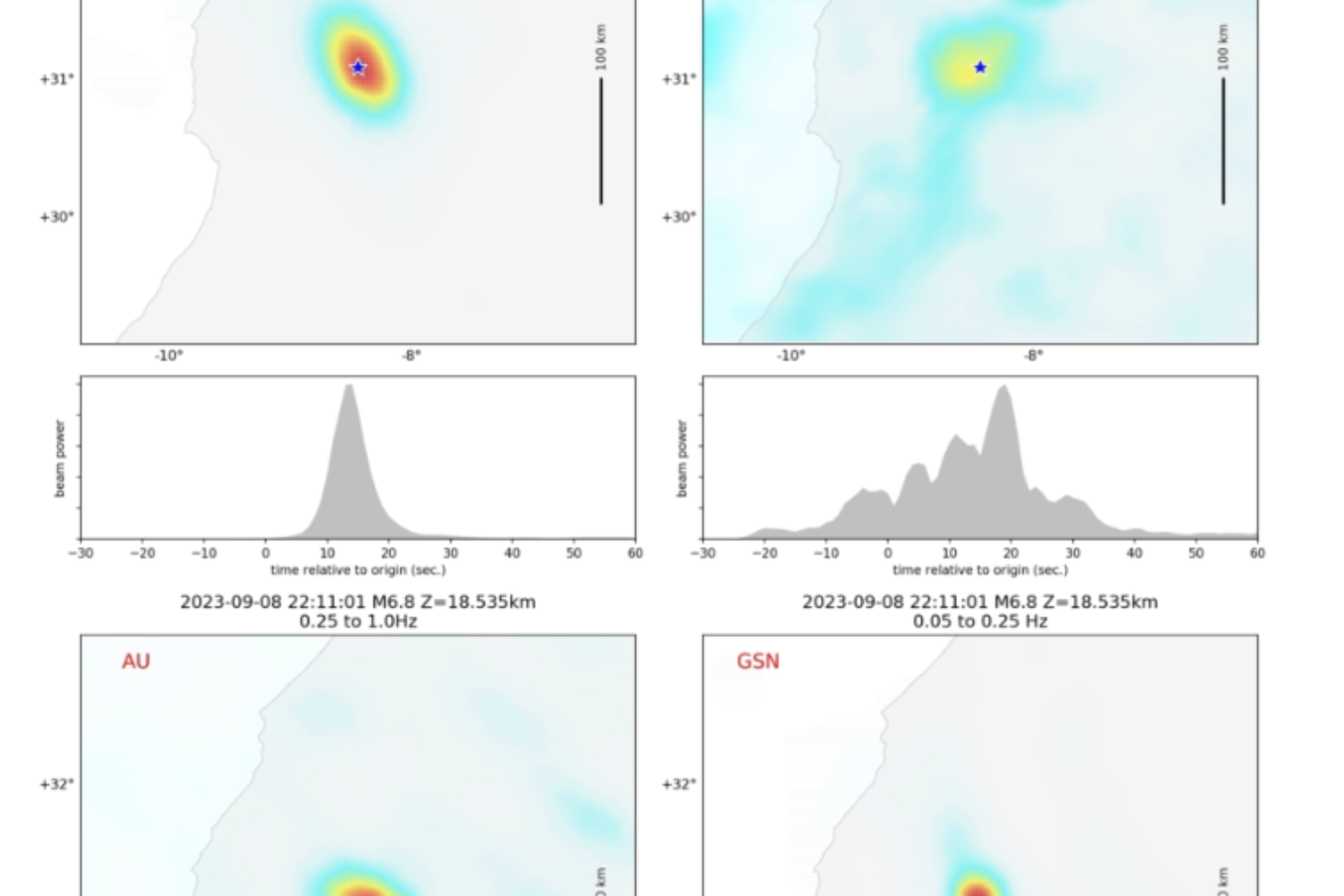
- Recent Earthquake Teachable Moments Used by educators across the globe, EarthScope creates educational content following significant earthquakes.For example, EarthScope posted a Teachable Moment presentation on the recent earthquake in Morocco, which includes a presentation to introduce the science and story of the earthquake and prompt a classroom discussion.“The timeliness of the ‘Teachable Moments’ content is HUGE,” says Pam Nelson, Geology Faculty at Glendale Community College in Arizona. “The teaching resources arrive within a day or two after a seismic event. I don’t have the time during the semester to produce materials of such high quality, so I rely on EarthScope. Students can see things ‘as they happen,’ which also queues them to ask more questions. My students and I have had deeper discussions about earthquakes and their hazards using ‘just-in-time’ data from EarthScope.”
- Plate tectonics
Teaching about the relationship between earthquakes, volcanoes, and plate tectonics can be enhanced through the use of GPS data. Given students’ everyday familiarity with GPS technology in their phones and other devices, this approach can actively engage them in the exploration of crustal movements by utilizing data from high-resolution GPS instruments. By observing shifts in vector lengths and directions, students can gain insights into the stresses a region is undergoing.
a. Introduction to Graphing GPS data | Lessons on Plate Tectonics
b. Exploring Tectonic Motions with GPS
c. Volcano Monitoring with GPS: Westdahl Volcano, Alaska - Interactive Earthquake Browser (IEB) is an interactive tool for exploring millions of earthquake epicenters on a map of the world. Students can query the database of millions of events based on earthquake magnitude, depth, timing, and location. Results are displayed on a map view where the students can toggle features like plate tectonic boundaries, terrain, or satellite mapping. Earthquakes can be freely rotated with the built in 3D viewer.

Teaching Moments: Recent earthquake from the EarthScope Consortium—M6.8 Morocco Earthquake
About EarthScope Consortium
EarthScope Consortium, which operates the U.S. National Science Foundation’s geodetic and seismic facilities (GAGE and SAGE), is dedicated to supporting transformative global geophysical research and education. EarthScope’s vision is an engaged society, resilient to geohazards, informed by geophysical discovery and global collaboration. EarthScope provides teaching and learning resources for Earth science, geosciences, geology, geodesy, and seismology appropriate for grades six through higher education, and it offers a variety of paid internships for undergraduate and graduate students and recent graduates. EarthScope publishes a monthly newsletter for science educators, earthquake news, and dozens of educational lessons, animations, and learning applications.